
The Geographic Gateway
A map of North America shows tall mountain ranges on the eastern side, standing between the ocean and the flat interior continent. Rivers flow down from these mountains, but most travel only east or south, which provides little help for travelers moving west. Central New York is different because a wide, flat valley cuts right through the mountains, allowing water to flow in two opposite directions.
The Mohawk River begins in this valley and flows east, reaching the Hudson River and eventually the Atlantic Ocean. Nearby, a small stream called Wood Creek flows west toward a large lake that connects to Lake Ontario and the Great Lakes system. The Great Lakes act like an inland ocean, opening a navigable path that boats could use to reach the center of the continent. Between the Mohawk River and Wood Creek lies a short section of dry ground. Although this piece of land measures only a few miles wide, it represents one of the most important geographic locations in North America.
The Oneida people understood the value of this dry ground long before Europeans arrived. The Oneida were one of the 6 nations of the Haudenosaunee Confederacy, a powerful political alliance that governed the region. They traveled the rivers in long canoes made from tree bark. A canoe moves fast on water, but a water trip stops when the river ends. The Oneida solved this problem by pulling their canoes out of the Mohawk River, lifting the boats onto their shoulders, and walking across the dry ground to Wood Creek.
When they reached Wood Creek, they put the boats back in the water and paddled west. The Oneida called this dry path Deowainsta. The word means "the place where canoes are carried." Because both rivers flow outward from this central high ground, travelers coming from either the eastern ocean or the western lakes had to paddle upstream against the current to reach this central gateway. By carrying their boats across this short strip of land, they connected two large water systems. A traveler could cross from the eastern ocean to the western lakes with only a short walk across dry dirt. This path made a door through the wilderness.
Therefore, the canoe path became a busy road for trade. Anyone who wanted to move goods across the continent had to pass through this narrow space. If a group of people controlled this ground, they could decide who passed and who turned back. The shape of the land made the path a natural gate.
The ground itself forced travelers to stop, walk, and meet whoever lived on the path. Over the next 300 years, this short piece of ground attracted armies, canal builders, and railroad workers. The future city of Rome, New York, grew right on top of the old canoe path. The moving water decided where the city would stand. Soldiers were the first arrivals to recognize this power.
The Military Corridor
When European nations arrived in North America, they recognized the rivers as natural highways for their military forces. The Dutch had claimed parts of this region first, but England took control of New York in 1664. After that, the English and the French competed to dominate the valuable fur trade. They both understood that whoever held the short walking path between the Mohawk River and Wood Creek would control the whole region. The water route offered the easiest passage from the ocean to the Great Lakes, so the quiet canoe path rapidly became a primary military target.
During the French and Indian War, the British army marched into the valley to block the crossing. The soldiers cleared trees and constructed a basic wooden fence around a cluster of supply buildings, naming the site Fort Bull. While a wooden fence works like a plug to block movement, it remains weak against a massive army. The French understood this weakness, marched through the forest, attacked Fort Bull, and burned the wooden walls to the ground.
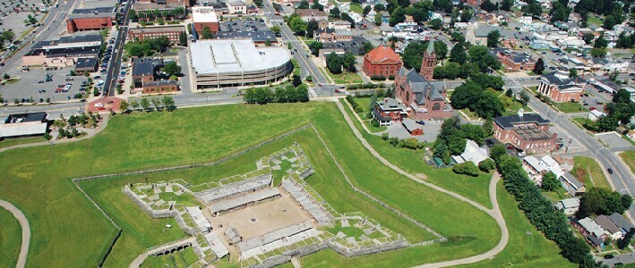
Following this defeat, the British learned they needed stronger walls and better architectural shapes to defend a valuable location. They returned and constructed a much larger installation called Fort Stanwix, designing it in the shape of a star. This star shape removed blind spots, allowing defenders at each corner to fire along the outside of the wall beside them. Attackers attempting to climb had nowhere to hide. The builders packed the angled walls with thick earth to absorb the impact of incoming artillery, which was heavy cannon fire. As a result of this intelligent design, Fort Stanwix stood like a fortress at the western edge of the valley.
20 years later, the American Revolution began, and the American army took command of the star fort. When the British army planned to invade New York, they intended to march east along the Mohawk River and cut the new nation in half. But when the British forces reached the walking path, Fort Stanwix blocked their advance. The American soldiers refused to surrender, prompting the British army to surround the walls and attempt a long siege, a strategy of surrounding and starving out a defended position.
Although the British tried to stop all food shipments, the Americans remained protected inside the thick walls. Meanwhile, local farmers and native fighters attacked the British supply lines hidden in the surrounding woods. The siege failed. The British could not bypass the fort because their boats and wagons could not travel through the wilderness. Eventually, the British army admitted defeat and retreated to Canada. The shape of the ground provided the Americans with the strongest tactical position to stand and fight.
The Canal Junction
After the military conflicts ended, the valley filled with a new population of farmers and merchants who built homes and cleared the land. These settlers needed to transport massive loads of wheat, timber, and stone across the region. While a horse can pull a small wagon on a dirt road, that same horse can pull a significantly larger boat if it floats on calm water. Recognizing this mechanical advantage, the state government decided to excavate a long, straight water channel called the Erie Canal.
The excavation began right in Rome. On July 4, 1817, workers pushed the first shovel into the dirt at this location, choosing Rome because it sat right at the center of the ancient water path. Over the next several years, workers cut a deep trench through the valley, permanently connecting the eastern ocean to the western Great Lakes.
When the Erie Canal officially opened, the old walking path disappeared beneath flowing water. The small military outpost transformed into a bustling center of trade, where long boats filled the canal and workers loaded cargo throughout the day. A few years later, engineers excavated a second channel called the Black River Canal, which ran north from the city into the dark forests of the Adirondack mountains. The builders required water from the northern rivers to keep the Erie Canal full during dry summer months.
The northern hills were incredibly steep, so the builders constructed over 100 locks to move boats up the inclines. A lock functions like a water staircase, lifting a boat one vertical step at a time. When the northern canal opened, workers harvested thousands of trees in the deep forests and floated the logs down the water stairs to the city. From there, the timber moved onto the Erie Canal and traveled either east or west to construct houses in expanding cities.
The city blossomed into a wealthy transfer point where two major water highways intersected. Workers from Ireland arrived to dig the channels and manage the boats, while the moving water inside the canals turned large wheels to power early machines. Business owners constructed the first factories along the canal banks. For 50 years, wooden boats transported grain, milk, and stone through the valley, proving that the old canoe path now controlled a vast network of moving water.
The Industrial Shift
Water transports heavy loads effectively, but it moves slowly, and winter ice halts the boats. When engineers laid steel railroad tracks across the valley, trains began transporting freight much faster than canal boats. The expanding railroads connected the town to large cities in every direction. Trains could operate all year long, crossing the frozen ground while the canals slept under the ice. Recognizing this advantage, business owners realized they could import raw materials from distant locations and manufacture finished products. The old canal town transitioned into a modern manufacturing center characterized by tall brick buildings and towering smoke stacks.
The business leaders constructed large factories because the town possessed three critical advantages. These were trains, canals, and running water for power. Rome operated as a major hub, pulling resources east and west and distributing goods to cities in the north. They ordered raw rock and minerals from deep mines located hundreds of miles away. Long trains delivered heavy loads of raw copper and zinc into the valley. Inside the brick factories, workers melted the metals together. Companies like Revere Copper and Brass and General Cable established extensive industrial operations along the canal banks. They produced everything from thick industrial cables to the famous copper-clad cookware found in kitchens nationwide.
The intense heat and loud machines required thousands of skilled hands to maintain production. Driven by this demand for labor, new waves of immigrants traveled to the city. Irish, Italian, Polish, and German families arrived to secure employment in the hot factories, establishing strong ethnic communities that shaped the local culture.
The town earned the nickname Copper City. This title originated from the transportation network that imported raw rock and exported finished metal, rather than from local mines. The geographic shape of the land allowed the city to gather materials from across the continent and shape them into valuable goods. Over the following 50 years, the government expanded the water channels again, excavating the substantial Barge Canal to support larger vessels. But the steel trains now carried the majority of the cargo across the valley. The fast trains and the new factories transformed the ancient canoe path into an engine of industrial production.
The Defense Center
When the Second World War began, the national military needed a location far from the ocean to repair military aircraft and store critical supplies. They selected central New York because the land was naturally flat and the transportation network remained strong. The military purchased a large area of flat ground and constructed concrete runways, naming the facility the Rome Air Depot. After the war ended, the military renamed the base Griffiss Air Force Base in 1948, honoring Lieutenant Colonel Townsend E. Griffiss, the first American officer to die in the European theater of the conflict. The aviation center brought a new type of worker to the city, filling the streets with radar engineers and technical specialists. The busy airfield hosted B-52 bombers, large cargo planes, and supersonic jet aircraft. The base served as a critical node in the national nuclear deterrence strategy, housing long-range bombers capable of reaching targets anywhere on the globe. The base also managed vital communication systems throughout the Cold War.
The military base pulled money and thousands of workers into the city from across the country. But while the airfield expanded, the older brick factories began closing their doors. New highways made transport trucks cheaper than trains, and foreign companies started producing copper and brass for less money. When this economic shift occurred, the city lost the factory jobs that originally built its wealth. The canal boats vanished, the train tracks grew quiet, and the city relied almost exclusively on the air base for employment.
Then, in the late 20th century, the national military decided they no longer needed the base. They closed the gates in 1995, removing thousands of jobs and leaving behind empty runways and silent buildings. The people in the city struggled to find new work, and many younger families moved away to secure jobs in larger cities. City leaders faced a difficult question. How do you replace an employer that large?
The answer came slowly, through the same geographic logic that had driven every previous change. The physical shape of the land still offered a flat, open space with strong road and air connections. Local leaders transitioned the old base into a modern business park. Today, the facility operates as Griffiss International Airport. The long runways accommodate large commercial aircraft, small private planes, and advanced uncrewed drones. Technology companies use the site to test aviation systems, develop cybersecurity tools, and operate data centers. The same flat ground that once served soldiers, canal boats, and factory trains now supports a digital economy.
The canoe path became a fort, the fort became a canal, the canal became a railroad town, the railroad town built an air base, and the air base became a business park. Over 300 years, the geography reshaped the city 5 times, and each transformation followed the same logic. The land offered the easiest route through the wilderness, and people built whatever the moment required on top of it.